
Soil horizons, layers in soil, are observed in soil pits or roadside cuts. Soil profiles, arranged in these horizons, are analyzed by soil scientists, or pedologists, to classify and interpret soil for various purposes.
Soil horizons are defined by visible properties like color, texture, structure, and thickness, while less visible properties like chemical and mineral content, consistency, and reaction require laboratory tests.
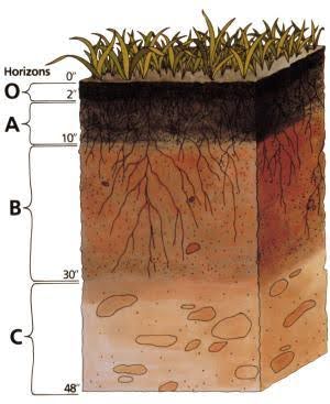
Soil scientists use capital letters O, A, B, C, and E to identify master horizons in soils, with most having a surface horizon. (A), subsoil (B), and substratum (C), and some having an organic horizon (O).Master horizon E refers to subsurface horizons with significant mineral loss. Hard bedrock, not soil, uses the letter R.
Project:
Soil Profile Cards
- Create soil profile cards on cardstock paper or note cards.
- Cut apart cards, attach carpet tape, remove tape at top, and place soil from the surface horizon to represent soil depth.
- Pull back tape for each additional layer, following the same procedure.
- The aim is to collect surface vegetation to comprehend the connection between plants and soil.

- Display soil types on a hill slope drawing or landscape using tape on a larger card or poster to demonstrate erosion severity.
Enjoy playing with soil!